“QGIS is a free and open-source cross-platform desktop geographic information system application that supports viewing, editing, printing,...
Bushwalking
Bushwalking, tramping, hiking…
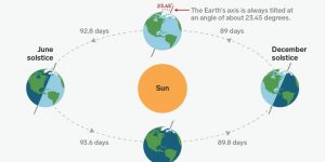
Before we calculate our Latitude (in the next post in this series) we have one vital concept...

On a fine and chilly Friday you buy yourself a compass. A nice, old fashioned manual one...
So, I was going to say “The Last Hike I Did” and add Before The Virus, but...

About 30 minutes south of Ballan, in the middle of the dry Brisbane Ranges, you’ll find the...
A ‘quick’ list of the main local Trips and Walks I did in 2019. Walks worth considering...

This is not directly related to Part 1, but similar concepts : you need to get the...

Something that happened today (see Part 2) reminded me when I first got a GPS. This was...
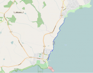
About 6.6 km total. Rankin Track quite steep. We had brunch at The Basin, then drove up...
An interesting question came up yesterday, what sort of good bushwalks can you do, that are accessible...